Month: January 2023
How to Create a Location-Based App: Ideas, Technologies, and Examples
Why are location-based apps important?
Location-based applications have been in trend for the past five years and aren’t going anywhere. According to Allied Market Research, the worldwide market of location-based services is expected to reach $318 billion in 2030, with projected CAGR of 24.3% between 2020 and 2030. Compare this to the only $36.35 billion this market was worth in 2020.
The main feature of location-based applications is of course detecting a user’s current location, and this feature helps businesses provide services, make relevant recommendations, promote their products, and more.
The worldwide market of location-based services is expected to reach $318 billion in 2030
Maps and APIs are the main technologies used in location-based applications. They not only track a user’s location but provide information about nearby objects, give directions, suggest relevant destinations, and offer useful details about them. Location-based services are used by lots of products, including in these categories:
- Ecommerce
- Car and scooter sharing
- Event organizations
- Restaurants and delivery
- Dating services
- Hotel booking apps
- Travel applications
- Photo sharing apps
- Social media
… and many more. Everything from suggesting the nearest restaurants and stores to finding people nearby can be done with the help of location-based applications.
Benefits of location-based apps
According to Statista, the main benefits of location-based applications for businesses are:
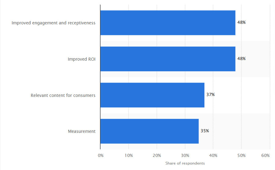
In a 2020 report, LBMA states that 98% of global organizations use location-based services to reach more customers. Here are some more benefits of location-based applications for businesses.
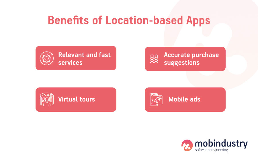
- Relevant and fast services. Apps like Uber or Grubhub use customers’ locations to provide the fastest service, for example by allowing customers to only order from nearby restaurants, thus guaranteeing fast delivery and increasing customer loyalty and satisfaction.
- Accurate purchase suggestions. Businesses are able to promote their services locally using location features, and they can also get more information about the users’ purchase patterns to suggest relevant products and services.
- Virtual tours. GPS tracking is one of the key technologies that makes virtual tours possible. It is often used in travel applications to increase engagement and suggest services while giving a tour around key city points. You can also power your app with AR and provide additional information on top of real objects.
- Mobile ads. Mobile advertising can be extremely effective when paired with geolocation services. By determining users’ locations, businesses can target nearby users with special offers or promo campaigns at nearby businesses.
Now let’s talk about the technologies that help businesses reach users based on their location.
Geolocation technologies
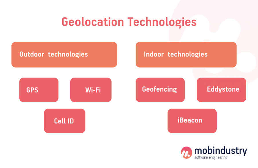
Most location-based applications use both location and mapping technologies. These technologies can be divided into two main categories: indoor and outdoor.
Outdoor technologies are used in apps for taxi services, food delivery, travel, and transportation. They locate the user and provide directions around the city and beyond.
Indoor geolocation technologies help to locate and track users inside buildings. These technologies are used in apps for hospitals, real estate, physical retail stores, museums, and smart homes. Let’s talk about the location-based technology examples in detail.
Outdoor geolocation technologies
There are three main technologies that help mobile applications track a user’s location:
- GPS
- Wi-Fi
- Cell ID
GPS
All modern devices have built-in GPS modules. Tracking a user’s location via GPS signal is the most accurate and fastest method, but a GPS signal is not always available.
Wi-Fi
Wi-Fi location technologies work just like GPS but in smaller areas. Google Maps and Google Places are two services that use this technology often.
Cell ID
Cellular stations are also used to find a user’s location based on the connections between cell towers and mobile phones.
There’s also a mix of GPS and Cell ID technology called Assisted GPS, or A-GPS. It combines both technologies and uses data from satellites and servers to deliver accurate geolocation data without draining the device battery.
Indoor geolocation technologies
Indoor geolocation works in buildings and requires more accuracy than outdoor geolocation because the movement inside a building is rather subtle compared to movement outdoors.
Below are the technologies used inside various buildings to help businesses give virtual tours and track when users enter stores or stop in front of a specific product.
Geofencing
Geofencing is a technology that creates a virtual fence around a location (usually a store) and utilizes GPS, Wi-Fi, and Cell ID technology to find users who enter this radius and are in close proximity.
Then, WHO can send these users notifications with special offers or promo campaigns happening at the geofenced location. However, geofencing can work in multiple ways. Here are the three main modes:
- Static — The geofencing feature is triggered by the user’s position relative to a certain place
- Dynamic — The feature is triggered by the change of the user’s position
- Peer-to-peer — The feature is triggered by the change of the user’s position relative to other users
One example of dynamic geofencing is when your smart home starts to control appliances when you’re driving home and approach the house. This can include turning on the lights, opening a garage door, and so on.
iBeacon and Eddystone
Eddystone and iBeacon are two similar technologies developed by Google and Apple respectively. They are Bluetooth-enabled tags that detect devices in close proximity and have lots of creative use cases.
For example, during a museum tour, as you approach different items, tags can react to your location and provide you with information about what you’re looking at.
Geolocation services and APIs
Now let’s talk about the services and best map APIs you need to integrate into your app for it to be location-based.
Android development
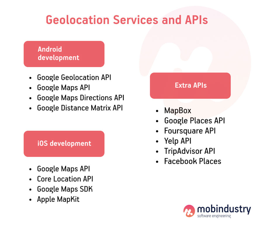
For Android applications, developers usually choose Google services like:
- Google Geolocation API — Uses data from cell towers and Wi-Fi hotspots detected by the mobile device, accurately showing the user’s location.
- Google Maps API — Shows maps with locations and objects.
- Google Maps Directions API — Allows users to get directions for different modes of transportation, from driving and public transport to walking and cycling.
- Google Distance Matrix API — Shows users the time and distance to a chosen location from the starting point.
iOS development
The iOS platform can use Google services, but it also provides its own APIs.
- Google Maps API
- Core Location API — Accurately determines device location, including orientation, altitude, and even proximity of near iBeacon devices.
- Google Maps SDK — Allows you to add all information from Google Maps to your iOS app.
- Apple MapKit — Allows you to use Apple Maps in your app. This includes all information about locations, map display, satellite imagery, and coordinates.
APIs from Google are the most popular choice among both Android and iOS developers because they offer lots of features. If you want to learn more about how to build an app with Google Maps, check the article below.
If you need even more location-based features, add these APIs to your application:
- MapBox — Digital maps that are a good competitor for Google Maps
- Google Places API — Especially useful for travel apps, as it provides information about various places nearby
- Foursquare API — Provides lots of information about venues with photos, reviews, and check-ins. Foursquare supports features like Snap-to-Place, which assigns users to specific locations, and geotagging.
- Yelp API
- TripAdvisor API
- Facebook Places
Types of location-based applications
There are several classifications of location-based applications. We’ll look into all of them.
First, there are real-time and non real-time applications, and the main distinction between them is whether they constantly track a user’s location. One example of a real-time geolocation app is Uber, as it constantly tracks both the driver and the customer while service is being provided. Non real-time geolocation apps don’t constantly track a user’s location, as it’s not necessary to provide the service.
Uber is a real-time geolocation app, as it constantly tracks both the driver and the customer while service is being provided
Location-based apps can also be classified as map-based or location-based. The difference between them is rather simple: if you see a map while using an application, it’s map-based. Map-based apps like Uber, Grubhub, and Google Maps show a user’s location and directions on a map.
Location-based apps just track a user’s location without displaying it on a map. Applications that use geofencing are location-based: they just need to know whether a user is in the target radius. Location-based apps like Tripadvisor show restaurants, hotels, and points of interest based on a user’s current location.
We can also classify location-based apps by purpose, and in the next section of this article you’ll learn about different types of location-based apps based on their services or goals so you can find the most suitable option for your own project.
Best location-based app ideas
There are many location-based apps that have already won the love of millions of users. Google Maps, DoorDash, Uber, Instagram, Tinder — these are popular applications from completely different industries, but they all have location-based features.
Let’s review the best geolocation app ideas depending on the industry, idea, and business model.
Ecommerce apps
Individual stores, retail chains, and marketplaces all use geolocation services to help users track their orders, deliver them to their location, and look up nearby stores. International ecommerce chains use geolocation to determine a user’s country so they can adjust the interface language, delivery information, and prices accordingly.
Some retail businesses that have physical stores also use geolocation and geofencing to target people nearby with special offers and promotions based on their location.
Food delivery apps
Food delivery has completely changed due to mobile and geolocation technology. In earlier days, people ordered delivery by phone and gave their home address, but they had no idea when the courier would reach their door.
Now, users can order food through a mobile app and track the courier’s location on a map in real time. Food delivery not only uses location tracking to give directions to a delivery person but also when recommending restaurants to users. A food delivery app can suggest only restaurants nearby to guarantee fast delivery.
Loyalty program apps
Loyalty program applications work for different kinds of businesses from stores to restaurants and use geolocation to send push notifications and track favorite places or the number of times a user visits a particular place.
Some loyalty programs reward customers for visiting stores a particular number of times and give them bonuses and discounts. This helps businesses attract customers to physical stores and encourages them to purchase products there.
Geosocial apps
Social media apps actively use location-based features. The most famous app to utilize geolocation — and one of the first — was Instagram. The Instagram app allows users to tag the locations of their photos, showcasing their travel experiences and finding people through geolocation as well.
Other apps like Twitter use geolocation to suggest tweets with news from a particular location. TikTok uses geolocation to suggest content and show a creator’s content to an audience from the same country or city.
Maps
The first application that comes to mind when you think of maps and navigation is probably Google Maps. However, currently there are tons of other mapping and navigation applications that have additional features or access to unique information about certain places.
Waze, MapQuest, InRoute Planner, 2Gis, and Maps.Me are just a few examples. Some of these apps are specifically designed for drivers and show traffic congestion, accidents, and road construction as well as gas prices. Others are developed for tourists and show places of interest with reviews and sights.
Map app development or navigation app development is a rather popular choice despite the competition.
Fitness apps
Fitness applications use geolocation for various purposes, but the most popular are providing routes for running, cycling, and other types of activities as well as for tracking walking distance and setting goals.
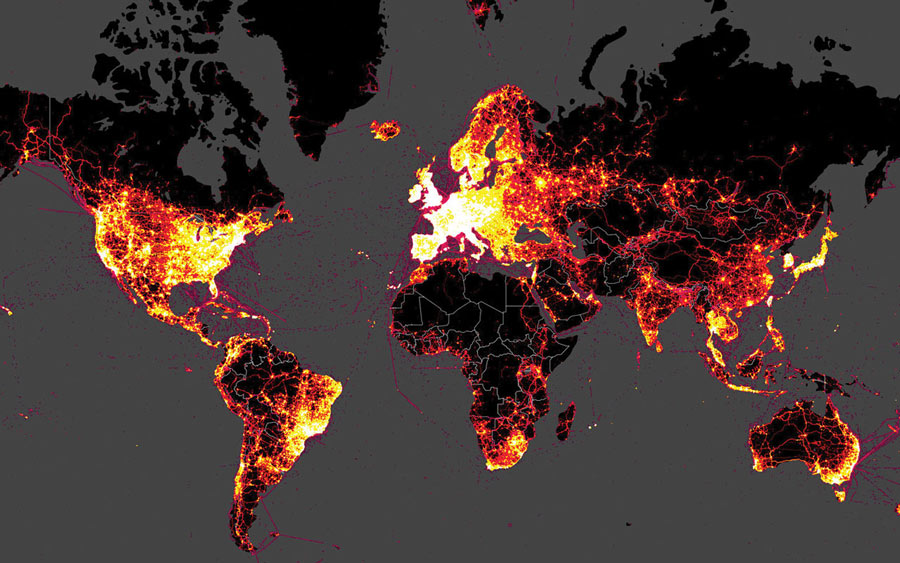
One of the most popular fitness apps with geolocation as a core feature is Strava. It helps users track activity and share their results on social media. With the Strava app, you can see all your activities on an interactive map.
On-demand services
On-demand services like any type of delivery, taxi, carsharing, and scooter sharing services are impossible without geolocation services. With maps, users can find the nearest cars or scooters to rent, create a route, and get to their destination in the best possible way.
If an on-demand service involves couriers, geolocation features help them to locate customers and deliver products as fast as possible.
Finding services
Whether you need to find your keys or track the location of your kids or relatives, finding services can help. They use geolocation to help you find anything on the map. Find my iPhone is one of the most famous apps of this type. It helps owners find a lost iPhone, iPads, Mac, AirPods, or Apple Watch through iCloud.
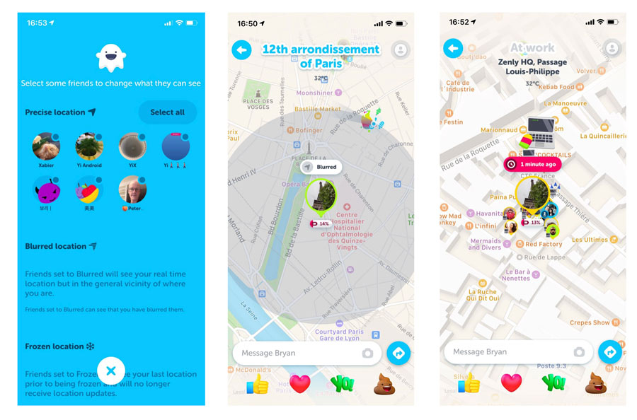
Zenly is one of the most popular apps that helps users mutually track friends and family members as well as look at their movement history. It’s convenient for meeting people and keeping in touch with them at any time.
During the COVID-19 pandemic, many governments and individuals developed location-based apps for tracking disease transmission and enforcing quarantine rules. Such applications also use geolocation for contact tracing, which in theory should help to slow down the spread of the virus.
Recommendation apps
Recommendation applications contain reviews and information about various places around the world such as hotels, restaurants, cafes, theaters, and museums. These apps are often similar to travel applications; however, locals use them too to find new places.
Yelp and Foursquare are two of the most popular apps of this kind, showing places in lots of different categories. In 2020, Yelp earned $872 million in revenue, and its current valuation is almost $3 billion!
Travel applications
Travel applications often have recommendation features and show the best times to visit certain places, the average cost of a visit, and other important information.
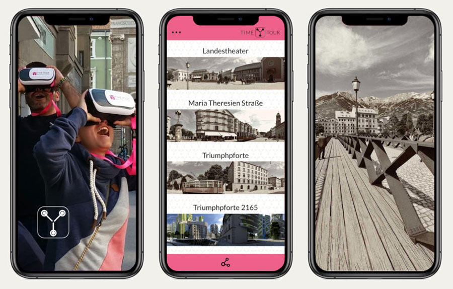
There are lots of unique features in travel applications that enhance the travel experience with the help of maps and geolocation. Augmented reality, virtual city and museum tours, recommendations on the best routes for city tours, transportation tracking, and offline map functionality are just a few of them.
Some travel apps like Airbnb also use maps and geolocation to help users pick the perfect accommodation. On the map, users can see how far a place is from the city center, the beach, and other points of interest.
Dating apps
Tinder was one of the first dating apps that successfully incorporated geolocation features into finding a match nearby. Because Tinder is often used for casual dating, it’s critical that matches are located in the same area.
Dating apps like Bumble, OkCupid, and Match.com also use geolocation features for finding matches nearby. However, many of these apps allow users to set their location to any country so they can find love overseas as well. On Tinder, this is a paid option.
Mobile gaming and AR
Mobile games with augmented reality actively use geolocation features to integrate gameplay into the real world, track users’ movement, and get them to catch virtual objects in the real environment. The first AR game that comes to mind is Pokémon Go, which took the world by storm in 2016. In 2021, Pokémon Go is still loved by thousands of people and is valued at almost $5 billion.
Now that we’ve reviewed the best location-based apps ideas and use cases for geolocation technologies, let’s find out how to make a geolocation app.
How to build a location-based app
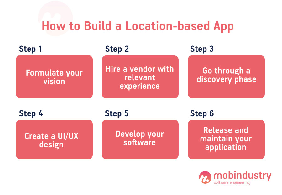
Step 1. Formulate your vision
The process of building a location-based mobile application is rather similar no matter what type of application you plan to develop. The first step is always formulating the vision. Even if you don’t know exactly what features you’ll need or how your future app should look, you need to have a vision for your product.
Think about your target market and audience and the problem your app is going to solve. You should also do market and competitor analysis so you know what’s already on the market and what the location-based app development standards are.
Step 2. Hire a development team
Now you need to find a team that will develop your application. Here you have a few options: hire developers in-house, hire freelancers, or partner with a development agency. I recommend the last option, as it’s time-saving and cost effective.
When working with a geolocation app development agency, you won’t need to worry about salaries, taxes, bonuses, equipment, and other expenses while getting a team that doesn’t need lots of management resources from you.
An outsourcing company can also help you save money for future marketing, as you can choose to outsource to a country with a relatively lower cost of living. Ukraine is one of the countries with the best price–quality ratio.
Step 3. Go through a discovery phase
A discovery phase is the initial planning phase of your product development. During this phase, you and a business analyst define your business goals and perform deep target audience analysis as well as market research and competitor analysis.
A business analyst at this stage will extract all your requirements and create a comprehensive technical specification that describes the ins and outs of your project, from technologies and features to key stakeholders and wireframes.
Step 4. Create a UI/UX design
Your team should definitely have a good UI/UX designer (or two separate designers) who will develop user stories and interfaces for your app. Don’t forget to also customize the map if you plan to use one in your application. A designer can come up with unique tag designs for different objects on your map to give it a personal branded touch.
Step 5. Develop your software
Now it’s time to develop your application. Your developers should suggest the best geolocation technologies that will suit your idea and integrate map APIs into your application.
I recommend always starting with an MVP, so make sure to prioritize your features and develop the most important core functionality first.
Step 6. Release and maintain your application
After all the final tests are done and your application complies with the rules of the App Store and Google Play Store, it’s time for the release. However, the work on your application doesn’t end here. To keep your software relevant, you need to constantly add new features, improve your app based on analytics, and support and maintain it.
Supporting and maintaining a location-based app includes updating libraries and third-party services and adapting your application to new operating system versions.
Location-based apps: Mobindustry’s experience
At Mobindustry, we have been developing applications for over 10 years, and lots of them have been location-based. Let me share just a few examples of what we’ve done for our clients and how location-based features have helped them provide great service for their customers.
International logistics app
We helped an international logistics company build a customer-facing application that allows customers to track their parcels, collect them from post offices, and manage them — for example, change the destination post office or personal information like home address, name, phone number and so on.
Geolocation features are important for logistics companies, and in this application we used mapping and location tracking so customers can track their parcels in real time. Maps also show the nearest post offices, and by tapping on an icon, a user can find the precise address, work hours, and the busiest hours.
Ecommerce app with location-based notifications
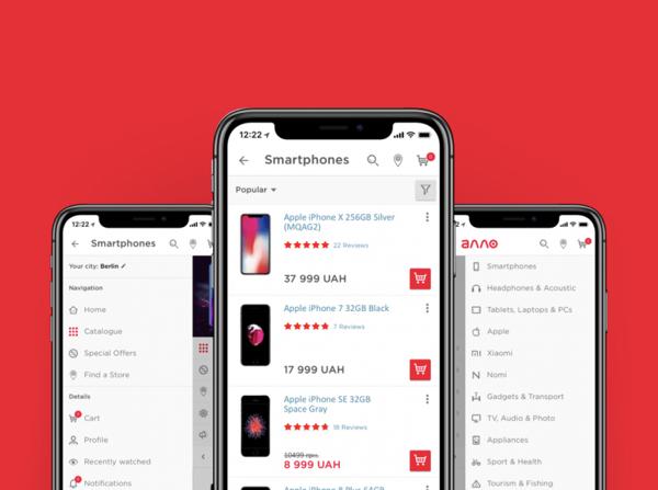
One of our clients is one of the largest retailers in Ukraine, with over 250 physical stores and a large online store. We created a mobile application for this retailer and added multiple geolocation features to it.
We integrated Google Maps and customized the map using the client’s brand colors. In the app, customers can see all the nearest stores, their working hours, and other details.
We also implemented location-based notifications to provide an online experience in the offline environment. Once a user is within a certain radius of a store, they receive a notification with a special offer from that particular store. This has allowed our client to attract more customers to their offline stores and increase sales by offering discounts and encouraging purchases.
Power bank sharing application
One of our clients is the founder of a power bank sharing startup. The sharing service is built around mobile location-based technologies. Geolocation tracking and maps are present at each stage of the customer journey.
First, the customer needs to find the nearest power bank station. These stations are situated in different parts of the city in restaurants, airports, museums, post offices, and other venues.
The application helps a user find the nearest station and then creates a route and gives directions. After the user rents a power bank, they can go around the city with it and charge their device. When they don’t need the power bank anymore, they can again find the nearest station on the map and get directions to it.
The map not only shows power bank stations but also indicates whether nearby stations have free power bank slots. Maps are also used in the feature that allows users to return a lost power bank to the nearest station in exchange for bonuses on future rentals.
These are only a few examples of the location-based apps Mobindustry has created over the years. If you’re interested in creating a location-based app for your business, don’t hesitate to contact us. We’ll help you at any stage of the development process, from the discovery stage to release and maintenance.

